‘Potentially life-threatening situation’ present over Aurora – PAGASA
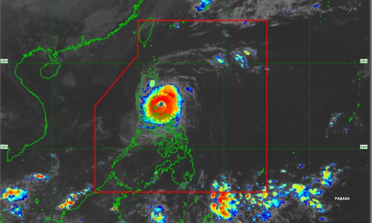
Metro Manila, Philippines — A “potentially dangerous and life-threatening” situation is present in Aurora as Super Typhoon Pepito is set to make landfall over the province on Sunday afternoon, state meteorologists reported.
In its 2 p.m. bulletin, the Philippine Atmospheric, Geophysical and Astronomical Services Administration (PAGASA) raised Wind Signal 5 over the central portion of Aurora, the southern portion of Quirino, and the southern portion of Nueva Vizcaya, as Pepito packed winds of 185 kilometers per hour (kph) and gusts of up to 230 kph.teorologists reported Sunday morning, Nov. 17.
“Ngayong umaga hanggang gabi, mararamdaman natin ‘yong peak ng matitinding hangin at pag-ulan at ‘yong high-risk ng storm surge na dulot ni Bagyong Pepito dito sa malaking bahagi ng southern Luzon, Metro Manila, Central Luzon at malaking bahagi pa ng northern Luzon,” PAGASA weather specialist Grace Castañeda said in a 5 a.m. briefing.
[Translation: From morning to evening, we will experience the peak of severe winds and rains and the high-risk of storm surge due to “Pepito” over large areas of southern Luzon, Metro Manila, Central Luzon, and northern Luzon.]
The weather bureau issued a storm surge warning with peak heights exceeding 3 meters over the low-lying or exposed coastal localities of Ilocos Region (western coast), Isabela, Central Luzon, Metro Manila, Calabarzon, Marinduque, and Bicol region.
Here are the areas under storm signals.
Signal No. 4: rest of Aurora, rest of Quirino, rest of Nueva Vizcaya, southern portion of Ifugao, Benguet, southern portion of Ilocos Sur, La Union, eastern portion of Pangasinan, northern portion of Nueva Ecija, and the northern and eastern portion of Polillo Islands.
Signal No. 3: southern portion of Isabela, rest of Ifugao, Mountain Province, southern portion of Abra, rest of Ilocos Sur, rest of Pangasinan, northern and eastern portions of Tarlac, rest of Nueva Ecija, northern portion of Bulacan, northern portion of Quezon including the rest of Polillo Islands.
Signal No. 2: rest of Isabela, southwestern portion of mainland Cagayan, Kalinga, southern portion of Apayao, rest of Abra, Ilocos Norte, Zambales, Bataan, Pampanga, rest of Bulacan, Metro Manila, Rizal, Cavite, Laguna, central and eastern portions of Quezon, Camarines Norte, and northwestern portion of Camarines Sur.
Signal No. 1: rest of mainland Cagayan, rest of Apayao, Batangas, northern portion of Occidental Mindoro including Lubang Islands, northern portion of Oriental Mindoro, northern portion of Romblon, Marinduque, rest of Quezon, rest of Camarines Sur, Catanduanes, Albay, northern portion of Sorsogon, and Burias Islands.
Rainfall outlook
Aurora, Quirino, Nueva Vizcaya, Ifugao, and Pangasinan will experience intense to torrential rains or over 200 millimeters.
Heavy to intense rains, about 100 to 200 millimeters, may be expected over Quezon, Isabela, Mountain Province, Kalinga, Benguet, Abra, Nueva Ecija, La Union, Bulacan, and Rizal.
About 50 to 100 millimeters of rain, meanwhile, will pour over Metro Manila, Ilocos Sur, Bataan, Zambales, Tarlac, Pampanga, Laguna, and Camarines Norte.
Another possible landfall
“Pepito” made landfall in Panganiban, Catanduanes on Saturday evening.
“Pepito” is seen to weaken into a typhoon before making another landfall over northern Quezon or central or southern Aurora between Sunday noon and afternoon.
It will cross Luzon and reach the coastal waters of Pangasinan or La Union on Sunday evening or early Monday morning.
“It must be emphasized that heavy rainfall, severe winds, and storm surge may still be experienced in localities outside the landfall point and the forecast confidence cone,” PAGASA warned.


